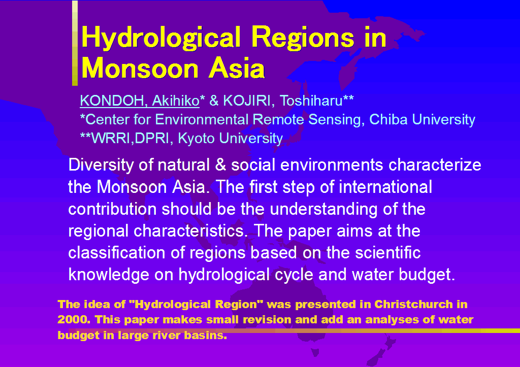
Hydrological Regions in Monsoon Asia
Akihiko KONDOH
CEReS, Chiba University, 263-8522 Chiba, Japan
Toshiharu KOJIRI
WRRC, DPRI, Kyoto University, 611-0011, Kyoto, Japan
ABSTRACT Monsoon Asia is characterized by the variability of natural and social environments. It ranges from humid tropics to arid regions and there are various hydrological phenomena occurring in such diverse regions. This study attempts to characterize hydrological regions of Monsoon Asia based on the water budget by using available global datasets.
Maps of hydrological region using several global datasets are created based on the following criterion:
- Region A1: water surplus all year around with surplus( ATS>400mm );
- Region A2: water surplus all year around with surplus( ATS<400mm );
- Region B1: water surplus with some months deficit ( ATD<200 mm );
- Region B2: water surplus with some months deficit ( ATD>200 mm );
- Region C1: water deficit with some months surplus ( ATD<200 mm );
- Region C2: water deficit with some months surplus ( ATD>200 mm ).
- Region D1: water deficit all year around ( ATD<200 mm );
- Region D2: water deficit all year around ( ATD>200 mm );
The extents of several large river basins are superimposed on the map, and examined for the flow regimes and water budget. The results well explain the regional characteristics of the river basins. The study shows the importance of spatial framework for the comparative hydrological study of river basins.
Key word Monsoon Asia; water budget, hydrological region, large river basins
Presentation OHPs
INTRODUCTION
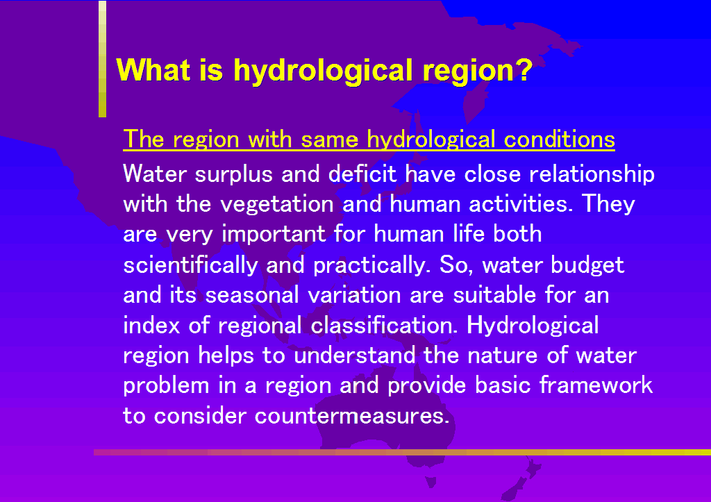
Hydrological processes on land surface and water resources management are strongly influenced by the characteristics of a region. Many reports on field survey or experiences of water resources management in the region are tend to be stored away in the vast amount of local studies. However, appropriate framework could help to collect and accumulate experiences of the regions and extract knowledge on comparative hydrology. A first necessity is the classification of the land surface to the region with same hydrological quality.
The region is defined as an extent with similarity in diversity, interrelationships, spatial and historical nature of the components which form the region. The definition of the region enables the accumulation of local knowledge as experiences positioned in the whole region and inherit them to the future. The region has hierarchy depending on the spatial scale. Global contains many regions, and a region also contains further sub-divided regions. There is a interaction between the regions, and it forms large scale environment.
Large gap seems to be exist between global and local scales to tiny individuals when try to recognize the world as a whole, however, the things which have to attach an importance are different in the scales. Climatic zones or differences in water budget are important in the global scale. On the other hand, so many individual matters specific to the region are important in a small scale. For instance, micro-topography such as natural levee or flood plain have a great influence on local water usage and management. However, even small scale phenomena can relate to the larger scale entity. For example, formation of fluvial geomorphology is influenced by the climatic zones, characteristics of the ground such as tectonic zone or stable land mass, through the formation of different sediments or rate of the debris production.
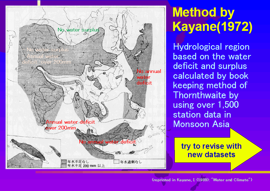
Hydrological division of Monsoon Asia based on the water budget is attempted as a trial to understand the region in the hierarchy of the global hydrological environments. Such a hydrological division was first attempted by Kayane(1972). He stated that specific way of water usage and water resources development are necessary for a region, and the knowledge on hydrological cycle and water budget should be fully utilized to avoid environmental degradation.
Hydrological region by
Kayane(1972) was the region with the similarity of hydrological conditions. As indices of the regional division, water surplus and water deficit, and their seasonal fluctuation were used for concrete and objective classification. Because water surplus and deficit have close relationship to vegetation growth and human activities, and contain important and practical meanings. Hydrological region helps to understand the nature of water problems in the region, and provides basic materials to make countermeasures for water problems. The purpose of this paper is to progress the idea expressed by Kayane(1972) by using new datasets and advanced computer technology.
Kayane(1972) put the emphasis on the characteristics of climatological water budget as a way of hydrological regionalization. Monthly water budget was calculated by the bookkeeping technique, first used by Thornthwaite(1948), for thousand of meteorological stations in Monsoon Asia, and made a map of hydrological region. This paper follows the Kayane's method, however, the current data and computer available for the calculation has progressed extremely now. This paper uses the global datasets open to Internet or contained in available CD-ROM, and make grid-based water budget map to draw new hydrological region in Monsoon Asia. The subject is classic, however, new understandings of Monsoon Asia is attempted using the idea of Geographic Information System(GIS) by combining various natural conditions.
DATA AND METHODS
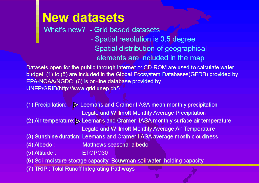
Global Datasets
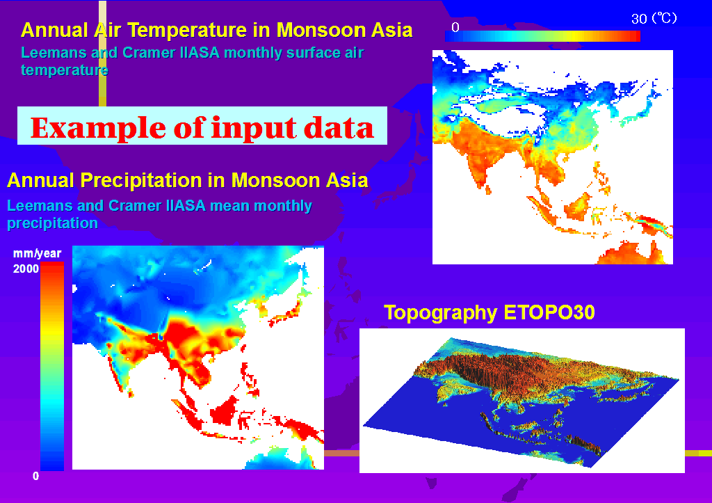
Table 1 shows the list of global datasets used for water budget calculation. These data are collected from WWW site and by ordering to dealing institutions. The datasets (1)-(5) in
Table 1 are contained in the Global Ecosystem Databases(GEDB) CD-ROM V.1(NOAA-EPA,1992). Dataset (6) is provided by UNEP/GRID through WWW site "http://www.grid.unep.ch/". Dataset (7) is a global river channel datasets available from "http://hydro.iis.u-tokyo.ac.jp/~taikan/TRIPDATA/TRIPDATA.html"(Oki and Sud, 1998).
The details of each dataset are available in the document files on WWW or in the CD-ROM. As for precipitation and air temperature, there contains two datasets. So the calculation was made for two combinations of datasets. Parameter set 1 uses Leemans and Cramer's and parameter set 2 adopts Legete and Willmott's. The accuracy of the datasets is not necessary guaranteed, however, the data are used because these data are currently the most advanced ones. Climatic data are the average of certain period, the results of the water budget denotes the long-term average, namely climatological values.
There are many grid data available with 0.5 degree latitude-and-longitude lattice. The water budget calculation is conducted with 0.5 degree grid. The coarse resolution datasets are simply divided to 0.5 degree grid, and fine data are aggregated to 0.5 degree grid.
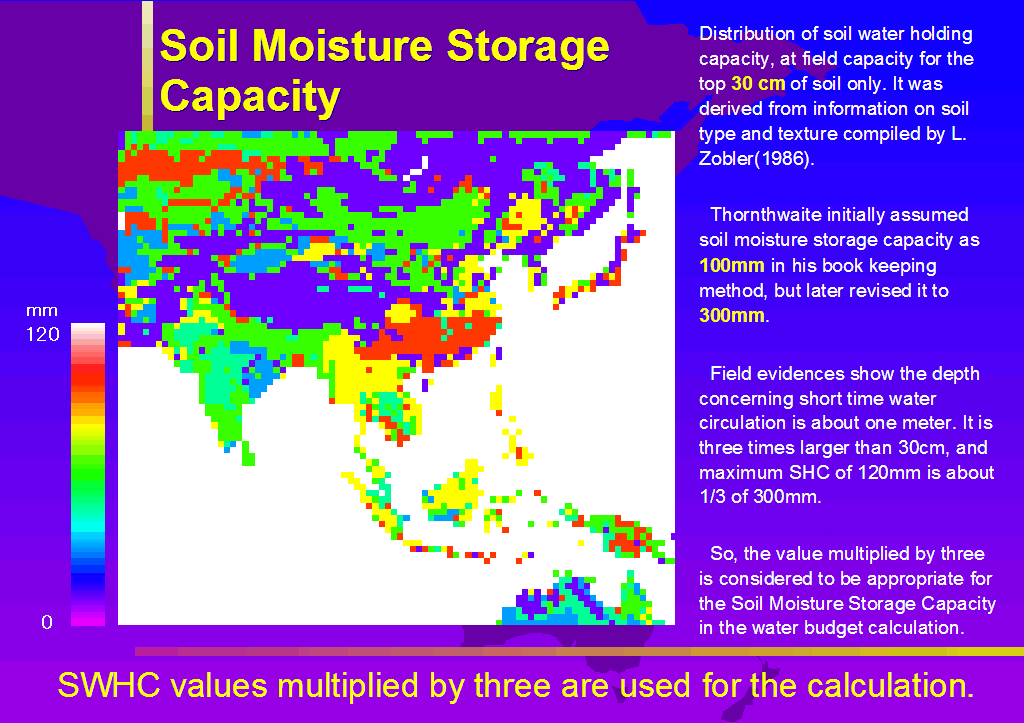
The dataset (6) is the water content in upper 30cm soil layer in field capacity.
Table 2 shows the value for several soil types. The maximum value is 120mm. Thornthwaite used 100mm initially as soil water storage capacity, and later revised it to 300mm. Compared with this value, the values in
Table 2 seems underestimated.
The root zone depth in the wheat field in North China Plain is about 1m(original data by the author). Zero-flux plane in Kanto loam formation, volcanic ash soil typical in central Japan, is about 1m (Higuchi , 1978). Numerical simulation shows the effect of evaporation reached 0.8 to 1.0 m depth after 10 days dry weather(Hillel, 1977). These observational and simulated results give propriety to consider the soil depth to be considered in short period water budget calculation is one meter. The maximum of soil storage capacity, Wc, value in Table 2 is 120mm and its double is close to the Thorthwaite's value. Soil depth of one meter is about the double of 30cm. Based on these examination, it is appropriate to consider that soil depth which is important to water budget calculation is one meter, and maximum soil water capacity is the double of the value in Table 2.
Evapotranspiration is calculated based on the grid-based global datasets. It is desirable to use the method based on the heat budget rather than empirical method. Thornthwate method(Thornthwaute, 1948) is widely applied in the world because it requires only monthly air temperature as input data. However, the assumption that the air temperature is the index of net radiation is hidden in the method. For the season when air temperature has less correlation with the net radiation, for example Japanese rainy season, Baiu, and for the area where air temperature has less correlation with net radiation, for example, humid tropics, the accuracy becomes not good(Kayane, 1972; Kondoh, 1993). Whereas the Penman method is based on the heat budget, however, it requires not only air temperature but also wind speed, humidity, and sunshine duration, and it makes hard to apply the method to grid-based global data.
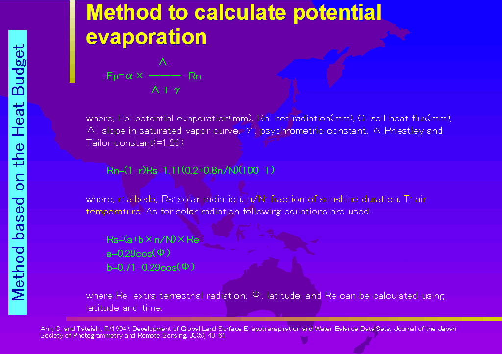
Ahn and Tateishi(1994a) developed the procedure to calculate the potential evaporation by using global datasets recently become popular. Basic equation is the one in Pleistley and Taylor(1972), and is based on the heat budget. By using the three raster datasets, namely, air temperature, albedo, sunshine duration, global evapotranspiration can be calculated.
Potential evaporation can be calculated as follows:
?
Ep = ? ?(Rn-G)
? ? ?
where Ep is potential evaporation(mm), Rn net radiation, G subsurface heat flow(mm), ? slope of saturated water vapor curve, ? , and ? is a constant. Preistley and Taylor(1972) obtained 1.26 for ? for large wet surface, and this value is used in this study. G is assumed to be negligible.
Ahn and Tateishi(1994a) obtained the combination of equations for the use of available global datasets. Net radiation is calculated as follows based on Linacre(1968).
Rn=(1-r)Rs-1.11(0.2+0.8n/N)(100-T)
where r is albedo, Rs is solar radiation, n/N is sunshine fraction, and T is air temperature. As for Rs, following equations are used:
Rs=(a+b×n/N)×Re
a=0.29cos(?)
b=0.71-0.29cos(?)
where Re is extra terrestrial solar radiation, ? is latitude. Re can be calculated by assigning the latitude and time.
The necessary data are air temperature, albedo, and sunshine duration. All these data are available as raster global dataset, so the grid based global potential evaporation can be calculated.
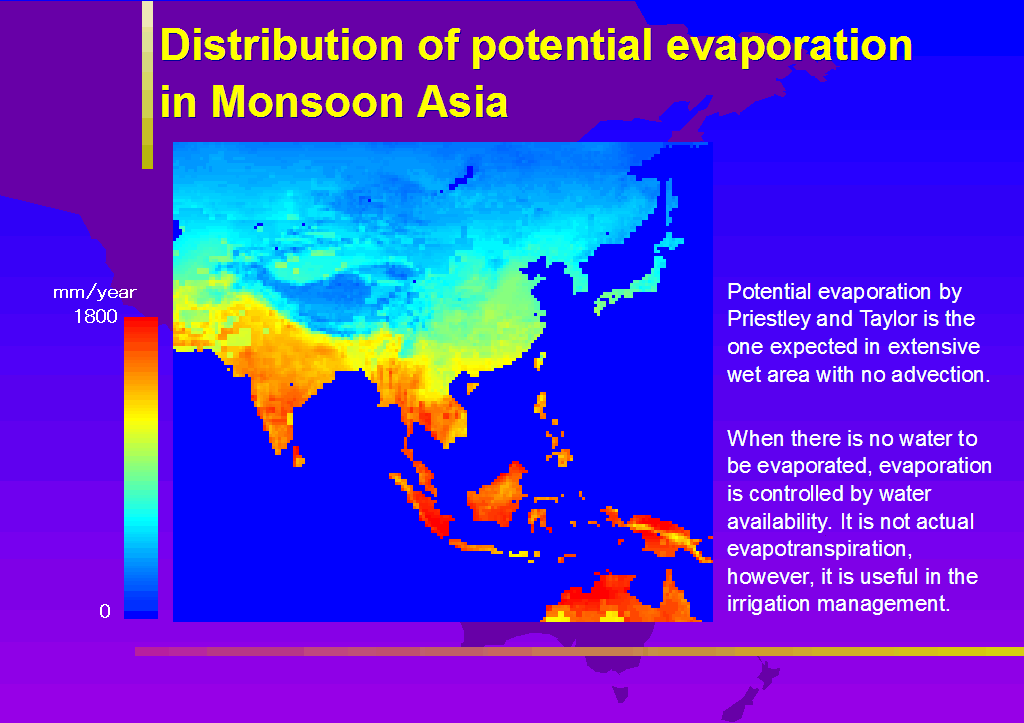
Potential evaporation by Priestley and Taylor(1972) is imaginary potential rate from large saturated plane without advection. Actual evaporation is controlled by water availability, simply soil moisture. Thornthwaite and Mather(1955) calculated the actual evapotranspiration by assuming the soil moisture storage capacity and got climatologically obtained monthly water budget. Ahn and Tateishi(1994b) adopted this method and produced grid-based global water budget map. The procedures are as follows.
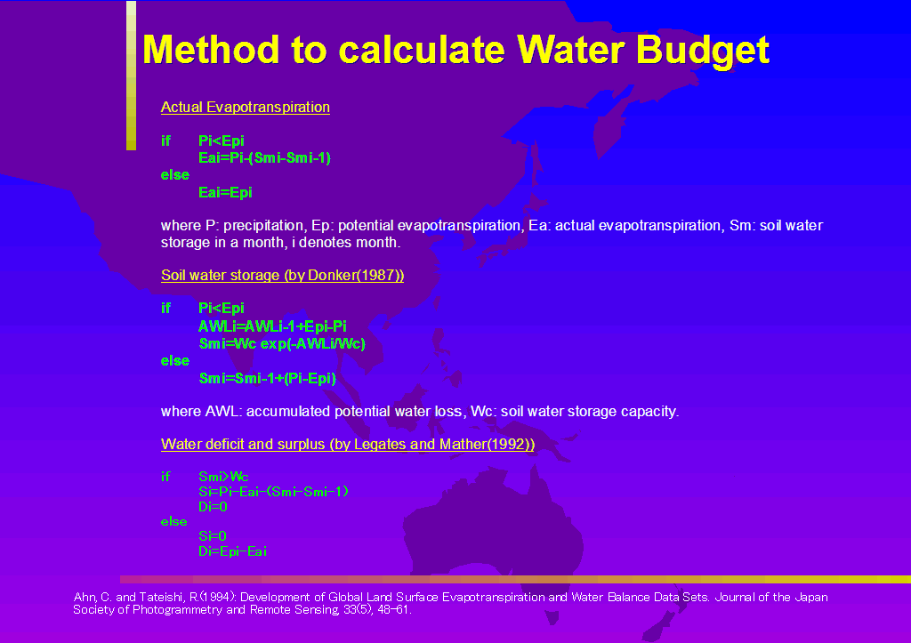
Actual evapotranspiration is first calculated by following algorithm:
if Pi<Epi
Eai=Pi-(Smi-Smi-1)
else
Eai=Epi
where P is precipitation(mm/month), Ep is potential evapotranspiration(mm/month), Ea is actual one(mm/month), Sm is soil moisture storage(mm/month), and i denotes month.
Monthly soil moisture can be calculated by the method of Donker(1987):
if Pi<Epi
AWLi=AWLi-1+Epi-Pi
Smi=Wc exp(-AWLi/Wc)
else
Smi=Smi-1+(Pi-Epi)
where AWL is accumulated potential water loss(mm) and Wc is soil water storage(mm). Soil moisture approaches zero but not fall below zero when AWL increase, so the parametarization simulates actual condition well.
Water surplus, S, and deficit, D, are calculated based on Legates and Mather(1992):
if Smi>Wc
Si=Pi-Eai-(Smi-Smi-1)
Di=0
else
Si=0
Di=Epi-Eai
The accuracy of the method mentioned above, especially the soil moisture estimation method, is hard to validate, however, the procedure is currently the best one using latest datasets. Further discussion is left for future study.
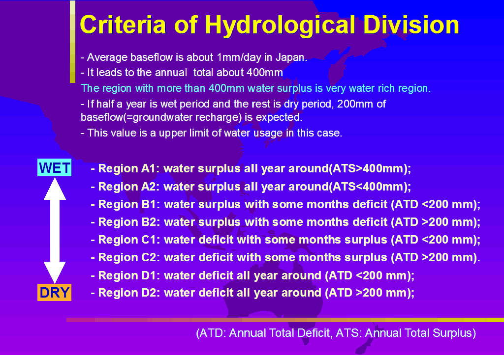
Classification of hydrological region in Monsoon Asia is attempted by using the water budget map calculated in the former section. The criteria is based on the water surplus and deficit, and 400mm/year of water surplus, and 200mm of water deficit are used as boundaries between the regions. The reason is based on the baseflow of the rivers in humid region(Kayane,1972). The average baseflow in humid region like Japan is about 1mm, so annual amount is about 400mm in round number. The region with more than 400mm of water surplus is very humid region. There is a report which reavels the annual amount of groundwater recharge is 913mm in the upland composed of Kanto Loam formation(Shimada, 1982).
Monsoon region has rainy season and dry season in a year. Provided the annual groundwater recharge (=baseflow) is 400mm in humid region, 200mm of recharge is expected in the wet season. Therefore, the upper limit of water usage is 200mm in a year, and the area with more than 200mm of water deficit is considered to be chronic water scarce area.
Based on the above standards, following eight regions are defined based on the water budget.
- Region A1: water surplus all year around(ATS>400mm);
- Region A2: water surplus all year around(ATS<400mm);
- Region B1: water surplus with some months deficit (ATD <200 mm);
- Region B2: water surplus with some months deficit (ATD >200 mm);
- Region C1: water deficit with some months surplus (ATD <200 mm);
- Region C2: water deficit with some months surplus (ATD >200 mm).
- Region D1: water deficit all year around (ATD <200 mm);
- Region D2: water deficit all year around (ATD >200 mm);
where ATS is annual total surplus(mm) and ATD is annual total deficit(mm).
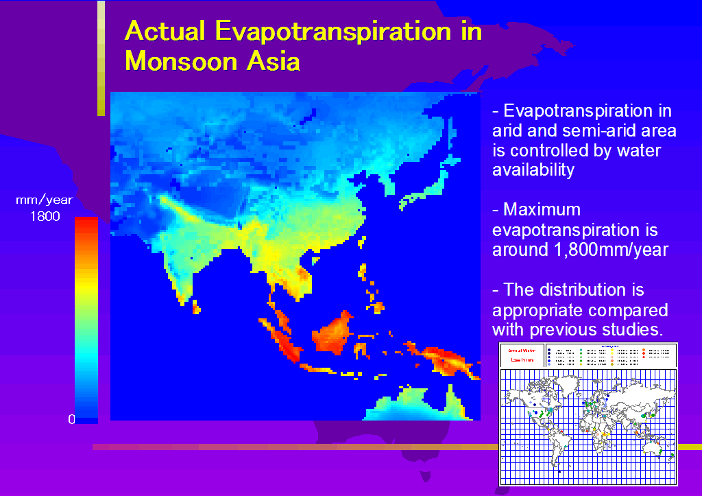
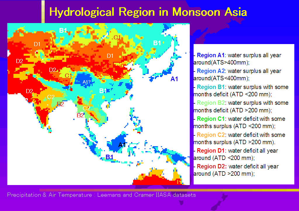
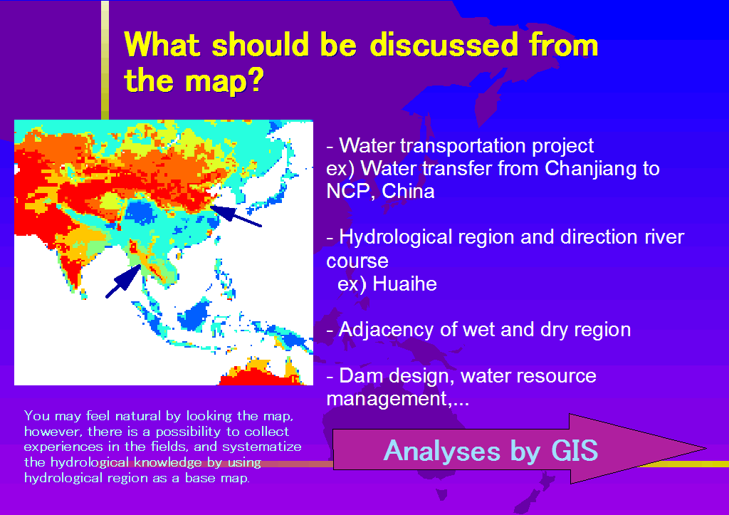
Figure 1 shows the map of hydrological region in Monsoon Asia with the parameter set 1. Although the details are different in some part, overall characteristics is the same between the parameter sets. Most wet region, A1, distributes in Japan, coastal area in east China, Borneo/Kalimantan, a part of Sumatra and Irian Jaya, and Papua New Guinea. There appears A1 region to the east of Tibetan Plateau, however, another precipitation dataset did not generate A1 region. This part is important because it locates at the upper reach of Changjiang and Mekong river.
The most of A region is occupied by A1 and the distribution of A2 is very limited. This means that the water surplus is quite large in the region with water surplus all year around. There is little transition zone, and that the wet and dry region lie in the proximity is one of the characteristics in Monsoon Asia.
The region B1, where water deficit exists but the amount is small, has large spatial extent. The west of West Ghats Mountains and Assam in India belong B1 region. These regions have large amount of precipitation, however, the rainfall concentrates on the wet season. This causes the water deficit in dry season.
The region B2 has large water deficit with some water surplus. The extent is east part of India, the area from Myanmar to Thailand along the Bay of Bengal, Rao PDR, and Cambodia. These area has distinct wet and dry seasons, and the precipitation in wet season is relatively high. The region B is considered to be the region where efficient operation of dams could produce augmentation in available water resources.
The region C1 has more water deficit than surplus but water deficit is relatively small. The extent includes Mongolia and part of Tibetan Plateau, and it cannot be seen in low latitudes. Whereas C2 region with relatively large water deficit distributes in Deccan Plateau in India, the leeward area of south-west monsoon in Myanmar and Thailand.
Water deficit lasts all the year in the region D. The region D1 is distributed to the north of Qinling Mountains and Huaihe River. D2 region distributed surrounding D1 region. In the southern Asia, D2 region distributes adjacent to C2 region lacking D1 region. It is important that D2 appears in Myanmar and Thailand surrounded by B region. The most part of North China Plain, the granary in China, is classified to D1 and D2 region. There is some concern about water problem that threaten food production in these area.
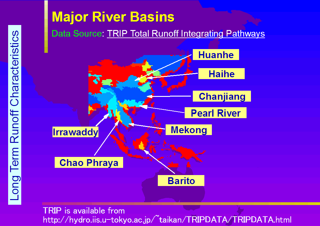
Monthly water budgets are calculated for the large river basins in east and southeast Asia.
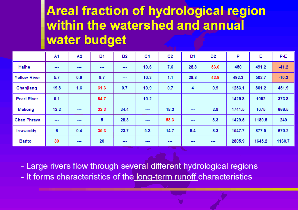
Table 3 shows the fraction of each hydrological region in the watershed with annual water budget in whole basin.
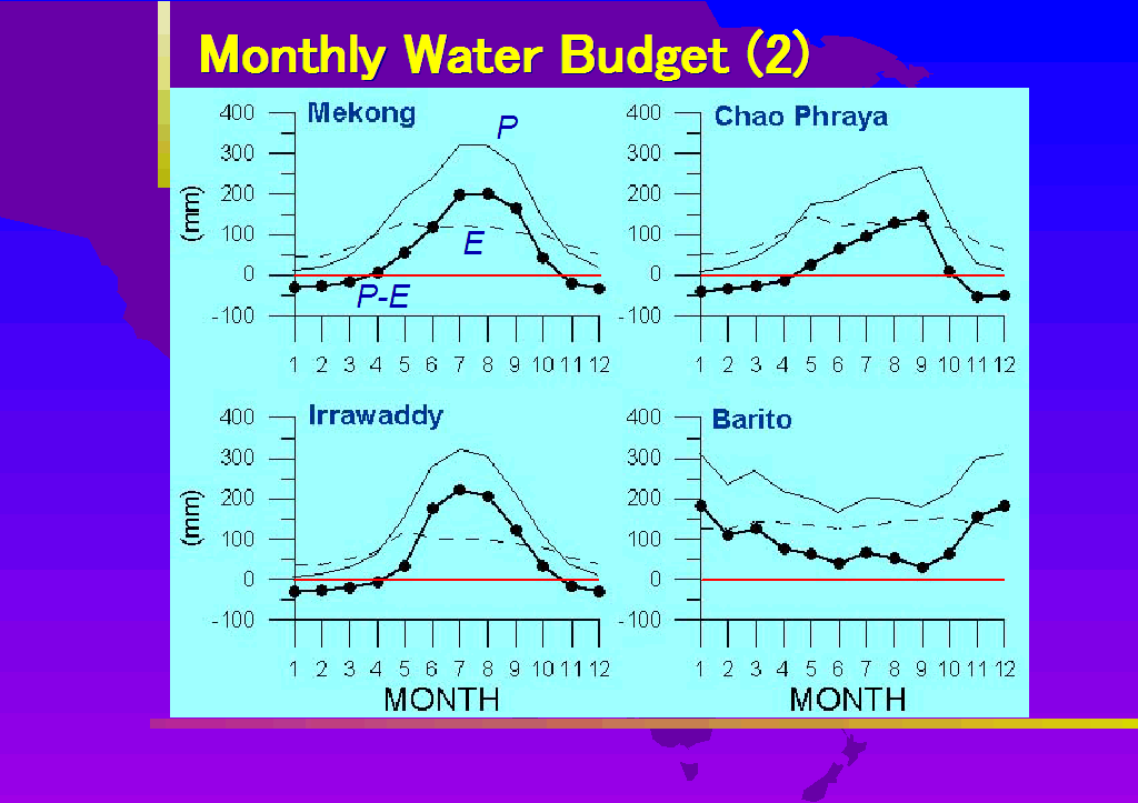
Each river flows down through plural hydrological regions. Annual water budgets in Haihe and Huanhe(Yellow River) are minus and D region occupies over 70% of the basin. Changjiang(Yangtze)River flows through various hydrological region, however, B1 occupies about 60% of the basin. Pearl River Basin is also dominated by B1 over 80% and is considered to have similar characteristics with Changjiang River. B1 and B2 dominate in Mekong River Basin, and considered to be wet basin, however, some C2 and D2 regions also include in the basin. It means there is seasonal water deficit, and the characteristics is almost the same in Irrawaddy River.
Chao Phraya and Irrawaddy are adjoining each other, however, hydrological characteristics are different. Dominated area is C2 in Chao Phraya, and it reveals the seasonal water deficit. On the other hand, about 60% of the basin is occupied by B region in Irrawaddy. Barito River is located in wet tropics, and annual water surplus is quite large. Most humid region, A1, occupies about 80% of the basin.
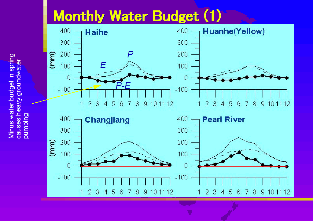
Figure 2a and
Figure 2b shows the seasonal water budget in each river basin. Water deficit occurs in spring to early summer in Haihe and Yellow River. Water surplus becomes low in winter season in Changjiang River and Pearl River, however, summer water surplus is large. Annual water budget is plus in Mekong, Chao Phraya and Irrawaddy, however, water deficit appears in winter season. Chao Phraya Basin is located in leeward area in southwest monsoon, and precipitation is relatively low in early summer, however, 30% of B region is included in the basin.
DISCUSSION
The different datasets lead to somewhat different result of hydrological division, however, the overall results from parameter set 1 and 2 produces the same results as a whole. The discussion here is based on the result from parameter set 1.
Japan, especially pacific side, is classified to A1 region, and it shows the Japan is very water rich country. A1 region can sustain water use unless water consumption exceed the water surplus in water budget. Even in A1 region, drought sometimes occur such as Tokyo. This is because Tokyo brings its domestic water from distant watershed through lengthy canal and river course. If water in a region is only used within a region, map of hydrological region gives fundamental information to perform appropriate water utilization.
In China, the region B and D are bordered with narrow C region extending from Huaihe, Qinling Mountains to western part of China. This border is called Qinling-Huaihe line, and is a border of crop area and paddy field area. Because Huaihe runs eastward, much rain water does not reach to North China Plain. The geographical setting is important to understand the hydrological region.
It is the characteristics in Monsoon Asia that dry and wet region adjoin each other. In this point, region D in Myanmar and Thailand is characteristics. The existence of river channel which brings water is very important in these region.
Water Budget of River Basins ***
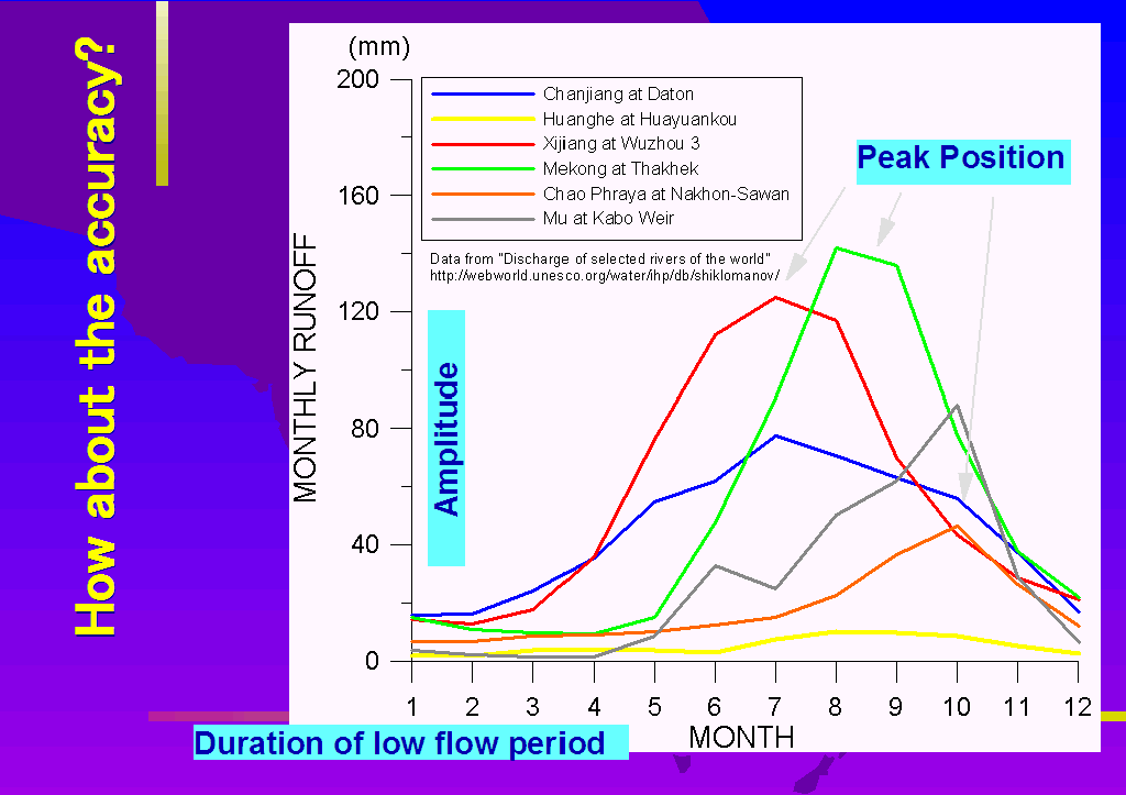
The selected basins located wide range from equator to N40°. Various land covers are included in the basin, however, main human activity is agriculture. Farming utilizes water and solar energy, so agricultural calender depends on seasonal variation of water and energy.
Water availability in the growing season is essential in mid latitudes because plants has a growing pattern depending on the seasonal variation of solar energy. For example, the water budget in Huaihe River Basin becomes minus from March to June. This period corresponds with the growing season of winter wheat, however, it is also dry season before Meiyu(rainy season). This causes strong dependence on groundwater which leads to water level decline.
Water budget is minus in Indian Peninsula, and groundwater resource keeps agricultural practice. The amount of groundwater is hard to estimate from surface water budget, it is at least understandable that the main water resources maintaining life is groundwater in the D region.
The storage amount of groundwater is large enough to maintain human activity for a certain period. However, groundwater usage exceeding its recharge causes minus water budget and leads to water level decline. The small rate of recharge means that the restoration of groundwater level takes very long time. Future perspective of the groundwater in D region is not so bright. The project in China that transfer southern water to north water scarce area is the project originating from regional circumstance.
In the low latitudes, energy for farming is enough, so water availability determines the productivity of agricultural practice. Large water deficit appears in dry season in Mekong, Irrawaddy, and Chao Phraya. The facility which smooth seasonal distribution of water increases the productivity.
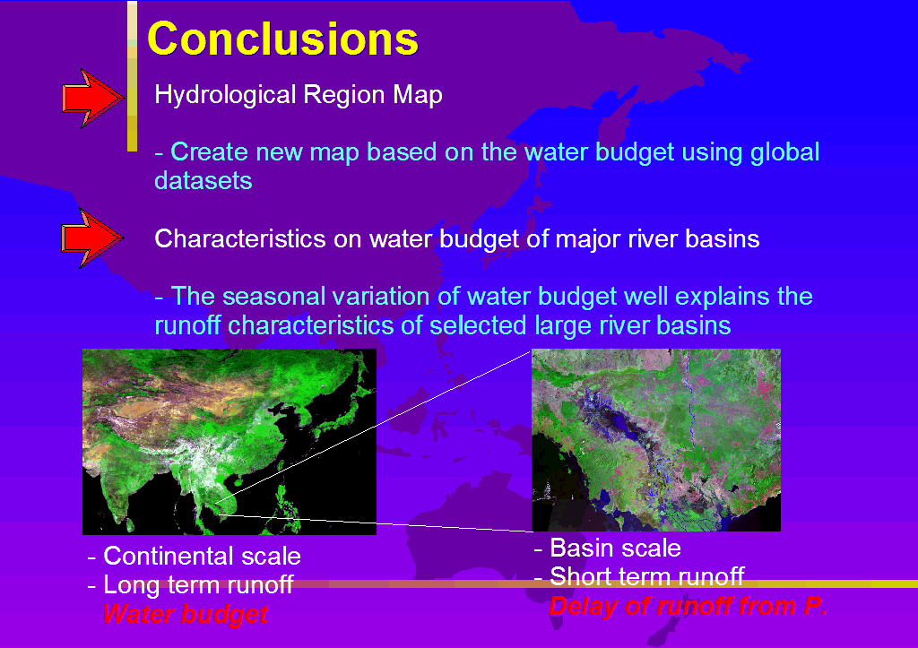
Map of hydrological map in Monsoon Asia is created from grid-based global datasets. Using this map, the characteristics of water budget in large river basins are described. The map can be used to understand regional characteristics from the viewpoint of water budget. Many local case studies have been done and will be done in future. Such regional studies can be extended to continental or global scale by putting each outcome on the hydrological region map as a base map of spatial information database.
The method to divide the region based on the water budget, however, is not the unique one. For example, Kayane(1972) stated another method that uses seasonal variation of river discharge. The accumulation of runoff data is enough currently, the method is realistic now. These information can also be stored in the database.
The local experiences which is located on the hydrological region can be accumulated as the knowledge base. It is a form of Geographical Information System. Its operation produces the understanding of regional characteristics. Creation of such a database is the next step of the study. Sound management and utilization of water resources never realized without proper understandings of regional characteristics.
REFERENCES
Ahn, C. and Tateishi, R.(1994a): Development of Global 30-minute grid Potential Evapotranspiration Data Set. Journal of the Japan Society of Photogrammetry and Remote Sensing, 33(2), 12-21.
Ahn, C. and Tateishi, R.(1994b): Development of Global Land Surface Evapotranspiration and Water Balance Data Sets. Journal of the Japan Society of Photogrammetry and Remote Sensing, 33(5), 48-61.
Bouwman, A. F., Fung, I., Matthews, E. and John, J. (1993): Global analysis of the potential for nitrous oxide (N2O) production in natural soils. Global Biogeochemical Cycles, 7, 557-597.
Donker, N. H. W.(1987): WTRBLN: A computer program to calculate water balance. Computer & Geoscience, 13, 95-122.
Environmental Protection Agency, U. S.(1992): Global ecosystem database ver 1.0. (on CD-ROM).
Hillel, D.(1971): Soil and Water. Academic Press, New York, 288p.
Kondoh,A., Nakayama,D., Tsujimura,M. and Kuraji,K.(1999): Construction of world basin water budget database. Journal of Japan Society of Hydrology & Water Resources, 12(6), 511-516.
Kondoh, A., Agung, B. H., and Runtunuu E. (2000): Comparative study on the hydrological characteristics in Asia and the Pacific. Proc. Fresh Perspectives on Hydrology and Water Resources in Southeast Asia and the Pacific, IHP-V Technical Document in Hydrology No.7, UNESCO Jakarta Office. 247-254.
Legates, D. R. and Mather, J. R.(1992): An evaluation of the average annual global water balance. Geographical Review, 82, 253-267.
Linacre, E. T.(1968): Estimating net radiation flux. Journal of Agricultural Meteorology, 5, 49-63.
Matthews, E.(1983): Global vegetation and land use: new high-resolution data bases for climate studies. J. Clim. Appl. Meteorol., 22, 474-487.
NOAA-EPA(1992) : Global Ecosystem Database Project, Global Ecosystem Database version 1.0 CD-ROM.
Oki, T. and Sud, Y. C. (1998) : Design of Total Runoff Integrating Pathways(TRIP) A global river channel network. Earth Interactions, 2, 1998(electronic journal)
Priestley, C. H. B. and Taylor, R. J.(1972): On the assessment of surface heat flux and evaporation using large-scaleparameters. Monthly Weather Review, 100, 81-92.
Shimada, J.(1982): Study of soil water movement in the Kanto Loam formation using environmental tritium as a tracer. Sci. Rep., Inst. Geosci., Univ. Tsukuba, Sec.A, 4, 25-67.
Thornthwate, C. W.(1948): An approach toward a rational classification of climate. Geographical Review, 38, 55-94.
Thornthwate, C. W. and Mather, J. R.(1955): The water balance. Publ. in Climatology, Vol.VIII, 1, 96pp.
Zobler, L. (1986): A world soil file for global climate modelling. NASA Technical Memorandum 87802, NASA/GISS, New York USA, 32pp.
Kayane, I.(1972): Hydrological Region in Monsoon Asia. Chirigaku-kenkyu-houkoku, Tokyo University of Education, 16, 33-47.
Kondoh, A.(1994) : Comparison of the evapotranspirations in Monsoon Asia Estimated from Different Methods, J. Japanese Assoc. Hydrol. Sci., 24, 11-30.
Kondoh, A., Tanaka, T., Tang, C., Sakura, Y., Shimada, J., Shibano, H., Liu, C., Zhang, W., Hu, C., Liu X., Chen j., and Shen, Y. (2001) : Water problems in North China Plain. Journal of Japan Society of Hydrology & Water Resources, 14, 376-387.
Tase, N.(2001) : Progress and problems in groundwater usage in high plain region, USA. Research Report of Water Resources Research Center, Kyoto University, 20, 87-100.
Higuchi, M.(1978) : Movement of water in unsaturated zone. Doctor's thesis, University of Tsukuba, 160p.